Day 1
Richard, Hotdog and I headed off approx 0900 and started making our way to Mansfield. This was the first time my eldest son and I had done a trip by ourselves (without the rest of the family) so I was looking forward to it.
The drive to Mansfield is bloody boring to be honest. I hate the highway runs, but unfortunately we have to do it to get to where it matters! 😥
We stopped a couple of times for fuel and a cuppa or two, but that was mainly it

Richard and Hotdog enjoying a break from driving

My young fella doing the same
We arrived at Mansfield at around 1300h to find pretty much everyone there. Had a look around the information centre and did the last refuelling before hitting the good stuff.

Young fella looking at the display outside of the information centre.
After hearing from Piston that he was still quite a bit away, we proceeded up to Craigs Hut. The run was quite easy and I only used low range for the climb up – and then mainly for comfort.

Craigs Hut

Craigs Hut

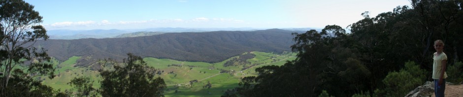
The views are fantastic

Tour group on horseback

From left – cewilson, Bluedog, Hotdog, Wholehog, Richard and Philm
After photos and admiring the view we dropped down to the King River and stopped at where the King River Hut used to stand.

What’s left of the hut
From there we continued following the Basin Rd into the Pineapple Flat Camping Area, where we called it a day.

Bluedog and Wholehog set up for the night

Richard set up
All in all a bloody annoying first half of the day, followed by some great weather and great scenery. Not a bad day by all accounts.
—————————————————————————————————-
Day 2
We woke up, had breaky, packed up and hit the track by 0900. We travelled back up to Craigs Hut as Piston couldn’t find it the night before.

The view in the morning

Not a cloud in the sky
From the hut we climbed down to Bindaree Rd and then on to Bindaree Hut. Along the way Richard found a fella that was lost so he decided to tag along with us for the morning – I bet he seen some of the country he never expected to see!

Bindaree Hut

Morning Tea
After a bloody good cuppa and something to eat, we backtracked and headed up to Bluff Hut. It was a nice climb up with the last part requiring low range. There were a few vehicles about (inc a D3 – starting to see them more often now), but thankfully they headed off pretty quick.

Bluff Hut

The view back to Mt Buller
We continued on to Lovicks Hut for lunch – well what’s left of it.

Lovicks Hut

The toilets still going strong though.
After lunch we headed up the hill and had a great view through the valley

The view
Continuing on we turned onto King Billy Track. Along the way we noticed a couple of rock slides.

Rock slide

Philm climbing up the hill
After navigating King Billy Track and Howitt Road successfully, we turned down Zeka Spur Track. It was here that our tag-a-long went his seperate way.

The old girl on Zeka Spur track whilst waiting for a Prado to climb up

Philm coming down Zeka Spur
Once down the bottom (note nearly 2 hours later) we proceeded to put up camp and have a soak in the river. The rest of the night was spent relaxing and having a few quiet ones.

Camp set up

The river

The river

Young fella burning off his energy (note I lost this ball on Herne Spur the next day, but you’ll have to wait for that explanation)
All in all a very enjoyable day, but long. If I was to do this trip again, I’d stay at Bindaree Flat near the hut instead of Pineapple Flat. It’d save you an hour straight up in the morning. That’s not having a stab at anyone, it’s a suggestion in case anyone plans a trip off of the one we have just done.
——————————————————————————————————-
Day 3
The morning arrives and we go through the morning ritual again. Once packed up we went and had a bit more of a look around the valley.

Most definately stuck out in the valley

Information plaque at the grave site
We headed out of the valley towards Herne Spur

Richard

Hotdog
We arrived at Herne Spur and up we went

Wholehog

Philm
Philm was nice enough to give me a lift back up to the top – it was after all quite a steep hill!

The view from the passenger seat

Everyone else taking photos of us coming up
It was here that my old girl threw a tanty – I think it was because I got a lift in a cruiser personally 😆
Anyway, what had happened was the fan shroud had come out of its mounts and was hitting the fan blade. This in turn caused the old girl to overheat as it climbed the last part of Herne Spur.
So 1/2 hour later the fan shroud was back in and I continued to climb up the hill. Thanks to Wholehog and Philm for the moral support
Downside is that I later realised that whilst the rear door was open, my young fella’s soccer ball from Santa (bright yellow Socceroo one) went skipping on down the hill!
Naturally there is no photographic proof of this from my end, but I’m guessing that someone would’ve taken photos – being that I was the only one without a cruiser!
Anyway, back with the story that matters:
We turned onto Cynthia Range Track and followed it for quite a few km’s. The views were fantastic, but all of them were blocked by trees which made it really hard to get a good photograph of it.
Took a left turn onto Station track which turned out to be a nice little downhill section at the end of it. By this stage we were alongside the Wongungarra River and travelling on the Racecourse track.

Left to right – cewilson, Philm and Wholehog

Young fella cooling down – it was a bloody hot day
We turned onto Crooked River Track just after the above picture and headed into Talbotville. Even with the overheating we had arrived at lunch time – a nice short day.

Camp set up

The river was the place to be that afternoon
After lunch and a swim I crashed and burned nana style. After waking up, my young fella was rapted to find kids that he could play with – he had been the only one since we left home

Good shot!
The rest of the day was spent lounging around, swimming, drinking, some dinner and sleep. All in all a nice short day to recharge the batteries.
——————————————————————————————————-
Day 4
Now where was I. Ah, that’s right – we are in Talbotville after a good relaxing afternoon, albeit bloody warm.
Next morning we got our act together and headed out via the Crooked River Tk. There was just a few river crossings to be made on the way to Bulltown.

Bluedog

Wholehog
I was considering going up McMillans Rd as I was worried about the radiator shroud (anything over 25-30 degree upslope caused the fan to hit it), but I was convinced by Philm to give it a go. As he said. if it overheats then we stop for a cuppa or two.
So we turned onto Bulltown Spur Track and started climbing. To be honest it’s not that bad a climb. We worked out that the track itself works out to be a 20 degree upslope across the length of it. However in real life it floats between 15 and 25 degree. The last part being the steepest.
Up the top of the climb we turned onto McMillans Rd and made our way to the old town site of Grant. It’s a nice little area with a lot of history – most of it detailed on signboards to make it easier. Morno’s was called 🙂

Morno’s at Grant
From Grant we continued along Grant Rd, stopping at the old Grant cemetery.

Grave site
After having a look at the cemetery (and good work by the Overlanders Club in VIC) we moved on down Dargo High Plains Rd to Dargo itself. Seemed weird to see a town (and bitumen) after what we had done so far. Thankfully the bitumen didn’t last too long! 😈

All of us lined up outside the Dargo Pub
Left to Right – Hotdog, Philm, Bluedog, Piston and wife, Richard, cewilson and son, Wholehog
After consuming a nice meal, consuming a couple from the tap, refuelling and buying supplies, we pushed on aiming for Haunted Stream for the night. We managed to travel along Upper Daego Rd alright, but turned the wrong way part way up.
We were originally planning on taking the Stock Route Tk and having a look at the Dog’s Grave. But we ended up on Jones Rd instead. Taking a quick look at the map, I suggested to Richard that we just take a right turn and cut across.
Well we ended up on Gidley Track which was a nice run through the ridge line with some good views. Came across some plants that lined the track, but there was a suggestion that it is in fact a weed that they may be trying to eradicate?

Sorry about the pic, it was taken out the windscreen whilst driving.
The next part I didn’t get any photos of, and I will apologise now. But to be honest I had my hands pretty full (no power steering, 1st gear low with rear locker engaged, and no air-con on a bloody hot day).
Note – I think I’ve got the following track names correct, but Richard will confirm.
We turned left onto Orton Tk. I remember the Heli Pad, then Richard telling us over the UHF that we might want 1st gear and it’s sliding a little. Being last I got to hear all of the ‘no crap’ comments, and the ‘yep I slid too’. I think I should’ve gone first 😆
Anyway I finally work my way down the hill. It was steep, very steep actually but the Maxi-Drive gears were brilliant. A little bit of sliding that slight acceleration took care of, and we were down the bottom pretty good.
Listening to Richard he was talking about the other side. Seemed he had climbed it in first gear. I found out later that he didn’t use the rear locker, but I wasn’t taking chances. So up we climb. The gradient was about what Herne Spur is (or slightly steeper), but there is no trees and nothing to stop you at all if it all goes wrong.
And to top it all off – this hill went for bloody miles. Well it felt like it. It took nearly 15 minutes to climb from top to bottom, the whole time looking at the sky or steeper stuff coming – on top of the fan hitting the shroud every now and again to keep me worried. And the funniest thing of all – my normally ‘chat happy’ son didn’t say a damn word. He just sat there and shut up.
Looking back at it now, it was probably the highlight of the trip. It was a good challenge, made more so by the fact that we didn’t have a clue what was coming other than what we heard over the UHF. Would I do it again – you bet, in a heartbeat. But it is most definately not a camper trailer area, or an area to visit in the rain.
Anyhow – after the climb out we turned right onto Mount Steve track paralleling the river for a little while. It was a nice little area, and it’d be good to go and find a camp for a few days there.
We turned left onto Waynes Tk which is very close to the Wentworth River. This in turn led right onto Calvi Lookout and another helipad (there is something about helipads and shortcuts) and then finally onto Jones Rd where we stopped to regroup and have a cuppa or three.
During the last hour or so of the tracks we had been getting some light rain at times that would come and go. Enough to make you think twice, that’s for sure.
After the cuppa we continued on down Engineers Rd and then Dawson City Tk before finally arriving at Dawson City. By now it was starting to definately become ‘beer o’clock’ and it was also the first day I hadn’t reached for a drink at midday 😯 Just goes to show how much I had been concentrating (and believe it or not – how much fun I was having).

Young fella having a ‘ah’ coke after a big day

Haunted Stream itself
Overall a great day with some very challenging tracks. The views were great along the way, but sometimes I didn’t get the chance to admire them
——————————————————————————————————-
Day 5
Normal ritual (breaky, pack up etc) and we were back on the track. The order for the morning was to go along the length of the Haunted Stream – nearly 50 times we would have to cross the river in a short time. So off we went headed for the old town site of Dogtown.

One of the exits from a crossing

Wholehog
We arrived at Dogtown, had a look around, took the obligatory photos and had a cuppa.

Haunted Stream at Dogtown
After this we continued along the Haunted Stream Track until we got to Dahlstrom Track. We stopped at a little clearing to have a bite to eat whilst we waited for everyone to catch up. Whilst sitting here Richard and I struck up a conversation about taking the Dahlstrom Track (as it looked like a shortcut 😆 ) across to Angora Range Rd.
A quick look on my laptop to make sure that it did indeed connect, and Richard headed on over. A little bit of trouble with a tree down made for some interest in the creek crossing. Basically you had to do a 3-5 point turn, avoid a tree on the left and a large rock on the right, drive across the river and climb up a little muddy bank.

Philm crossing 1

Philm crossing 2

Philm crossing 3

Philm crossing 4
From here we climbed up the hill, turned onto Angora Range Rd and then turned left onto the Great Alpine Rd. We continued through Ensay and stopped at Swifts Creek for a bite to eat and some supplies.
After raiding the local bakery we continued on up to the Cassilis Historic Area stopping at King Cassillis Mine

King Cassilis Mine
After having a look around the relics, we took a look down at the Charlotte Spur Tk/Powers Gully Tk intersection. The Charlotte Spur Tk was closed and there wasn’t much point in climbing Powers Gully Tk, as we were headed the opposite direction. By now it was starting to get bloody hot, so Ben and I had a quick dip in the creek to cool down.
With the decision made, we headed back out and continued on through Cassilis to Omeo. Just before Omeo there is a little place called the Oriental Claims Historic Area. Richard had been there before, and had actually been trying to remember where it was.
So of course, in we went for a look.

My young fella on the swinging bridge
Whilst everyone was looking around, we decided to duck down to under the bridge to jump in the river – which we duly did. And it did cool us down for around 5 minutes

Under the bridge
From there we followed the lead and climbed up to the lookout at the same area

View from the lookout

Another view from the lookout
After this we all ducked into Omeo for a look around. Ben and I discovered that the rest area down there actually has a 3m deep pool (river), so of course we spent a bit of time in there. By the time we got out we realised that the others were starting to move. So towels on seats and off we went.
A quick run back down the Great Alpine Rd and we turned left onto Bindi Rd. Winding through the hills we made our way to the ‘Washington’. This was a steam driven winch during the 60s that used to haul timber out of the surrounding gullies.

Now that’s a pulley

My young fella and Bluedog looking at the winch

The old girl still going strong
After this we climbed our way down to the Moscow Villa Hut. Inside there is a story detailing the life of ‘Bill Ah Chow’ a local bushman who also used to man the fire tower.

Moscow Villa Hut
We set up camp down on the Bentley Plain. It has to be one of the best areas I’ve seen to set up with facilities that are top notch. Seeing as it was still early, we had a quick bite to eat and then headed back up the track to the Mt Nugong fire tower.

Mt Nugong Fire Tower
After a few photgraphs we climbed back down to camp, had a bit more to eat and drink and called it a night. Not a bad day at all, and a nice easy pace. I was still tired from the day before, and the heat during the day was starting to get to us – even had me thinking about putting air-con in the old girl.
——————————————————————————————————-
Day 6
During the night we had quite a good lightning storm. Certainly made for some viewing and not much sleep. I awoke to hear Wholehog and Bluedog packing up (at like 0600) and wondered what the hell they were doing. I took a look outside the tent and realised straight away.
The sky outside was black as the ace of spades and there was a little bit of wind about. So up I get and wake the little fella up. What followed was one very quick pack up. Fed the boy and we headed off – thankfully with no rain yet.
We travelled along Nunniong Rd for quite a while making some good time. Reaching Native Cat Tk we turned right and followed it along. About 3/4 of the way we decided to stop for a cuppa.

Native Cat Tk

Philm
After filling the tummies up, we continued to the end of the track and turned left onto Limestone Rd for a short while. It was short because 4km’s later we turned right onto Limestone Creek Tk. It is a nice area along here with some good camping areas.
Climbing up McCarthy’s Track had it’s moments due to some traffic in awkward places and it was very damp (raining in some sections) but nothing that difficult. Clearing to the top of the track we turned onto Davies Plain Tk.
My mudflap decided it would call it a day so it got thrown on the roofrack (where it still is actually). The weather had really closed in and visibility was two tenths of stuff all. It wasn’t cold enough to snow, but the fog was certainly thick along the top. We seen the sign that said Davies High Plains – but that was about it.
After what seemed like was forever (it wasn’t) we made it down to Davies Plain Hut

Davies Plain Hut

Info on the hut

Holding yard
Deciding to push on for lunch due to the weather, we kept on travelling down Davies Plain Tk towards Tom Groggin

The weather was clearing as we climbed down
We continued climbing down to Buckwong Creek

Crossing at Buckwong
Dogmans Hut is ten minutes up the track and once there we set up – knowing that we had a few days now where we didn’t need to pack up of a morning.

My dinner cooking
The end of a ‘mixed bag’ of a day. Started with storms, went into some light rain, some heavy fog, then overcast conditions finishing of with some good weather. The tracks were good and camper trailer friendly although heavy rain could change that.
At the end of the day I had managed to meet Slowhilux and wife for the first time, and caught back up with 98GU and met his extended family. A few quiet drinks and bed was the order.
This was the end of the extended trip. Many thanks to those that came along and had a good time. Thankyou.