Day 7
The plan today was to go up to Davies Plain Hut return. Due to the fact that those of us on the extended trip had come through there the day before, and I needed to refuel etc Richard and I decided to head up to Thredbo.
Richard and I headed off mid morning. We crossed the river and continued up the Alpine Way towards Thredbo. Along the way we decided to stop and have a look at Leatherbarrel Creek (rest area), having drove past it a number of times.

Leatherbarrel Creek
Continuing on we climbed up to Dead Horse Gap

Richard

Dead Horse Gap
We continued on to Thredbo where we filled up with fuel. The price of diesel there is absolutely bloody disgusting, and a blatant rip-off. Nearly 30c dearer than Jindabyne (not even 30km’s up the road)
The young fella and I got our shopping done, and with Richard staying for a early lunch we headed off by ourselves. We stopped up the road at the start of the Cascade Hut walk.

Looking up towards the mountains

Big Boggy creek
Climbing back down the mountain we decided to have a look at the Tom Groggin side of the river. There were a lot of people camping down there, and the majority of them with camper trailers.

Murray River – looking from the NSW side
Heading back we went and had some lunch, have a fish and then a swim to cool down. After lunch we decided to go for a run back out to Buckwong Creek for a look, and to get some more charge into the second battery.

The view down to the Murray River from the Davies Plain Track
Along the way we met up with a group having a ride up the track. They were heading up to the hut for the night, having left Tom Groggin station earlier on.

Touring the High Country by horseback
Buckwong itself is a nice little area. It is far enough from Tom Groggin to get away form the crowds that tend to congregate. It has good water in the creek, and a nice fireplace. The only downside maybe that it doesn’t have a toilet.

Buckwong Creek
After having a look around I gave the boy a driving lesson. He completed his first river crossing and first hill climb – a major achievement in any boy’s life!
Coming back we ran across some wildlife – thankfully not literally.

Little black snake
Back at camp I got the campfire going nice and early to get some coals going.

Dinner cooking
Whilst dinner cooked, we went around and caught up with how everyone around the place.

The view across Tom Groggin station
We also had some extra peple camping around us. A group of four or five camper trailers came down and joined us at Dogman’s Hut – many others turned up and left.

One of the fella’s off of AULRO
All in all – a nice relaxing day and some good time spent with the young fella.
——————————————————————————————————–
Day 8
We headed of mid morning. The plan for today was to visit a few of the local mountains. Heading out via the Tom Groggin track we travelled through a mixture of tight loose rock and forestry type trails. It really is a quick easy run through compared to the other way I normally go (that being the mountain run I’m about to talk about).
Arriving at Buenba Flat we stopped for a cuppa and a bite to eat.

Morno’s at Buenba Flat

Buenba Creek
From here we climbed up Buneba Rd until we reach the turn-off to Mt Gibbo Tk. This used to be quite overgrown last time I was in the area, but it is a lot easier going now. The track itself can be a bit slow (esp if wet) but 2nd low and good tyre pressures normally see you through Ok.
The last bit entails a nice steep climb, but certainly easier than what we had already done during the extended trip.

The view from Mt Gibbo

Mt Gibbo Track

Mt Gibbo – 1750m – 22m shorter than Mt Pinnabar
From here it’s a downhill, a bit of a flat and then a climb up to Mt Anderson – all of it a reasonable run in low range.

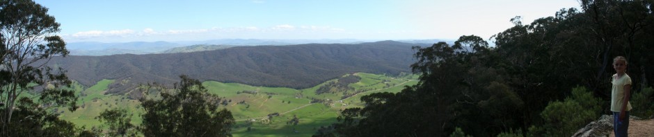
My young fella at Mt Anderson – 1650m

The view from Mt Anderson
We decided to push on to Mt Pinnabar for lunch, as it was only just approaching midday at this stage. Still travelling along Mt Gibbo Tk, we came across a small stick in our way. Slowhilux and I went over, and then Wholehog did some quick track repairs to help the standard vehicles over.

Typical situation in the high country.

Wholehog building it up – note what’s happening though, as sometimes this is the next best solution to turning around if you don’t have a chainsaw. So simple, but not normally though of.

Even when building it up, there isn’t that much room to play with (Hotdog)
The last part of Mt Gibbo Tk (just before you meet Mt Pinnabar Tk) is a nice little uphill part. It isn’t anything bad but enough to drop down to probably 2nd low.

Slowhilux climbing up Mt Gibbo Tk
Turning left onto Mt Pinnabar Tk we completed the last couple of little climbs to the top of the mountain. Lunch was taken at this great place.

Great view, great place, great day and great company. The top of Mt Pinnabar

Left to right – Slowhilux, Bluedog and cewilson on Mt Pinnabar

The kids enjoying the trip point. Elevation = 1772m
After lunch we climbed down Mt Pinnabar Track back to camp. The run is easy enough, just make sure that you slow down for the long downhill sections. Especially the part from the Stony Creek Tk junction on – please use 1st low going down there and don’t try it in the wet.
All up the run took just over 5 hours. The rest of the day was spent relaxing in the Murray River, having dinner and a few quiet drinks.
——————————————————————————————————
Day 9
This was to be a nice short day. Wholehog and Bluedog headed off to Thredbo to do the climb up to the summit.
Joff slept in and decided to go for a run up to Thredbo himself.
The rest of us – well we decided to venture into NSW territory ourselves. We crossed the Murray River and turn left onto the Great Alpine Rd. After watching a couple of P platers in 4WD’s and a camper van becoming an angry pack (and I mean it was getting angry) we turned into the Geehi Rest Area.
Everyone availed themselves to the toilets and then had a look around. The Swampy Plain River looked a treat and Geehi Hut was quite popular.

Geehi Hut

Swampy Plain River
After a good look around we continued on by crossing the Swampy Plain River. A little further up the track and you arriver at Keebles Hut.

Keebles Hut
 ]
]
Keebles Hut
Next up was the second crossing of the Swampy Plain River

Crossing the Swampy Plain River
Just around to the left is the Old Geehi Hut. I have a little bit of history with this hut, having enjoyed a night or three in the confines during the colder months.

Old Geehi Hut
 ]
]
There is some great fishing to be had here sometimes
Whilst there we cooked up and had some lunch. Just some history for those that don’t know – there are five huts along Geehi Flats, however only three area accessible by vehicle. The other two (Doctors Hut and Dr Forbes Hut) are accessible by foot only.
All five huts are built of river stone that was carted across. There are some signs that detail this in some of the huts. The sheet iron was brought in and was cut into half size sheets so they wouldn’t get caught on tree branches. Hence why they look a bit odd.
Anyway – back to the trek. After lunch we travelled up the track and turned left onto Geehi Walls Trail. There is no need for low range through any of this – however be aware of washouts and the occasional drainage ‘hump’ on the trail.
After about 10km’s you turn left onto Major Clews Trail. You used to be able to continue straight ahead and come into the back of Murray No.2 – but this has now been closed.
Almost straight away you arrive at Major Clews Hut. I strongly recommend going and having a read of the information that is there, or at least doing a Google search on him. The amount that he achieved in his lifetime is a credit.
With regards to the hut, he hand built it himself out of mud brick. Quoting the words out of ‘The High Country’ book – “it’s isolated site typifies the Major’s love of the bush and his dislike of modern society.” This is very true.

Major Clews Hut

Memorial
Whilst at the hut, we were advised that the track out to the highway was blocked by a tree down. So being the trusting souls that we are, we continued driving out towards the highway. 😆
To be honest, there was a tree down. And in an X-trail I can understand the advice. However in our vehicles – just added a little excitement to the track.

I stopped for this little fella along the way

The tree

And the way around. Lightning stikes had caused a number of trees to fall in the area
The rest of the run out to the highway was nice and easy – all still in high range. Slowhilux headed back to camp and the rest of us decided to pay a visit to Khancoban. A nice ice cream and drink later and we were feeling nice and refreshed.
We found out that Murray 2 no longer does tours, and is in fact closed down to the public. So we continued on towards Murray 1.

The lookout
We went down to have a look at the Information Centre. Whilst there we found out that they do tours of the station, so we took some photos and joined the tour.

The view across to the station

Inside the station

The old girl out the front of Murray 1
The tour (albeit short) was very informative and helps you to understand the Murray side of the scheme. I recommend it to anyone, especially because it’s free. 🙂
On the way back Richard called over the UHF and said that Scammels Lookout was worth dropping in to. I have to say that I agree.

Scammels Lookout
Dropping back into camp we joined nearly everyone else in the river

Murray River at Dogmans Hut
The rest of the night was spent cooking dinner, getting ready for our departure the next day and having a quiet drink and chat around the campfire.
—————————————————————————————————–
Last day
Everyone headed their own little direction.
However Richard, Hotdog and I – well we went for a little meander first.
We crossed the mighty Murray for the last time and turned towards Khancoban. The run across was nice and uneventful. We stopped in the drop of some rubbish and continued on our way.
Now I haven’t managed to drive the Khancoban to Cabramurra road yet, so this was my first time. The start of it was nice and easy and a pleasant drive. There may or may not have been an incident where a certain rear door opened and a bottle of oil dropped onto the road (no photos, no proof) 😆
Anyway, back with the real story. We continued climbing until we came across Tooma Dam – and it looked a treat.

Tooma Dam

Tooma Dam

Tooma Dam
The climb up from Tooma Dam is nice and easy and there area some great views along the way in a few places.

View on Tooma road
Up near the top you come across O’Briens Hut. It’s a nice little rest area for lunch or a cuppa. For interest, a little bit further up the road is Manjar Trail which will give you views down onto Cabramurra if you continue onto Black Jack Trail.

O’Briens Hut

O’Briens Hut
We continued on to Tumut Pond Dam. A couple of guys had parked down the bottom of the dam and had a tinnie in there fishing – wonder if it’s any good?

Dam Wall

Tumut Pond Dam

Tumut Pond Dam
We went into Cabramurra and had a quick look around. We tried to get something to eat from the shop, but the line-up was ridiculous. Having only ever been there in Winter before, I got quite a shock with regads to how many people were there! 😯
So we continued on to Three Mile Dam to have some lunch. And why wouldn’t you with a backdrop like this.

Three Mile Dam

Three Mile Dam
After a nice lunch of egg and bacon sandwiches, we backtracked a little to the start of Lobbs Hole Rd. The original plan was to do Browns Trail and the Powerline Rd into Talbingo, but we had all done it before – so the plans were modified slightly.
Having also only done this trek in winter (in snow to be more precise) I got quite a shock to realise that the whole track is rock, and a lot of it quite annoying. Hint for anyone travelling it – drop tyre pressures. It’s real bumpy at road going pressures! 😳

Lobbs Hole Rd Lookout
We continued on climbing down until we got to the valley. There is some great camping to be found in the velley alongside the Yarrangobilly River, although be aware that there are no facilities available there.

Down in the valley
Climbing up out of the valley you pass Lobbs Hole (which is part of the Talbingo Resevoir). You can turn off and head down into there – it’s meant to be quite good for fishing.

Talbingo Resevoir
The climb out to the Snowy Mountains Highway was rocky and bumpy. To be quite honest I was happy it was over. A combination of not lowering my tyre pressures, and quite a few days on the road were culminating real quick by the time I finished it. But finish it we did, without any damage too.

Finished

The young fella had had enough by then
We turned left onto the Highway and climbed down to Talbingo. I was reminded real quick that I was back on main roads when a car decided to overtake me on the straights (when I was going well and truly on the speed limit) and then made me hit the brakes all the way down the bloody hill. Sometimes it really is tempting to just give that little nudge! 😈
But I didn’t and we successfully made it down safely. I showed Richard the little camping area where I tool the family last year and he decided to call it a day and set up camp. Richard, Hotdog and I bade our farewells and headed off our seperate ways.

Last photo just outside of Talbingo
The run home was great – long weekend traffic and all. But I got home without killing anyone and managed to unpack the old girl before I ran out of light. Work the next day killed me! 😥
All up though, another great trip. The company was excellent and the terrain – well I think that the pictures tell more than a thousand words.